

Chesterfield Boulevard runs right along the Elizabeth River just east of downtown Norfolk. The river’s water level in the 1920s, according to sea level rise measurements, was about 14 inches lower than today. Over decades, the sewer system underneath the ironically named Chesterfield Heights neighborhood has slowly degraded. The land has subsided, and wake from river traffic has gradually eaten away at the shoreline, making communities particularly vulnerable to even sunny day flooding. Relative sea rise includes many far-ranging factors that contribute to increased flooding like sinking land, historic real estate development patterns, tide cycles, and an ancient meteor strike, which is playing out all across the water’s edge in Norfolk. If the projections of climate scientists are accurate, it is not a question of if but when Norfolk’s low-lying areas become inundated. Hemmed between a rising river, the highway, and active industrial sites, Chesterfield Heights and the adjacent neighborhood of Grandy Village have become an unlikely testing ground for 21st-century stormwater and flood management strategies. The area is now home base for one of the most extensive, highest-profile public works schemes in recent memory. How increasing rates of sea-level rise will play out is an open question that comes down to a block-by-block basis.
For Norfolk, flooding is part daily nuisance (flooded roads and basements), part existential crisis (an economic system wary of flooding risks, mass exodus to higher ground). The Army Corps of Engineers recently released plans and renderings for an extension of the Downtown Flood Wall with a price tag exceeding a billion dollars. When complete, the Chesterfield Heights project will be a pioneering piece of the new generation of flood defenses. Designed to withstand rising waters, a network of massive artificial barriers, tidal gates, berms, floodwalls, and levees, the project’s coverage will span key inlets of the Elizabeth River, like the Hague and the mouth of the Lafayette. If things prove successful, there will eventually be added infrastructure in Ghent, the Harbor Park area, and an expanded downtown floodwall protecting a redeveloped St. Paul’s District.

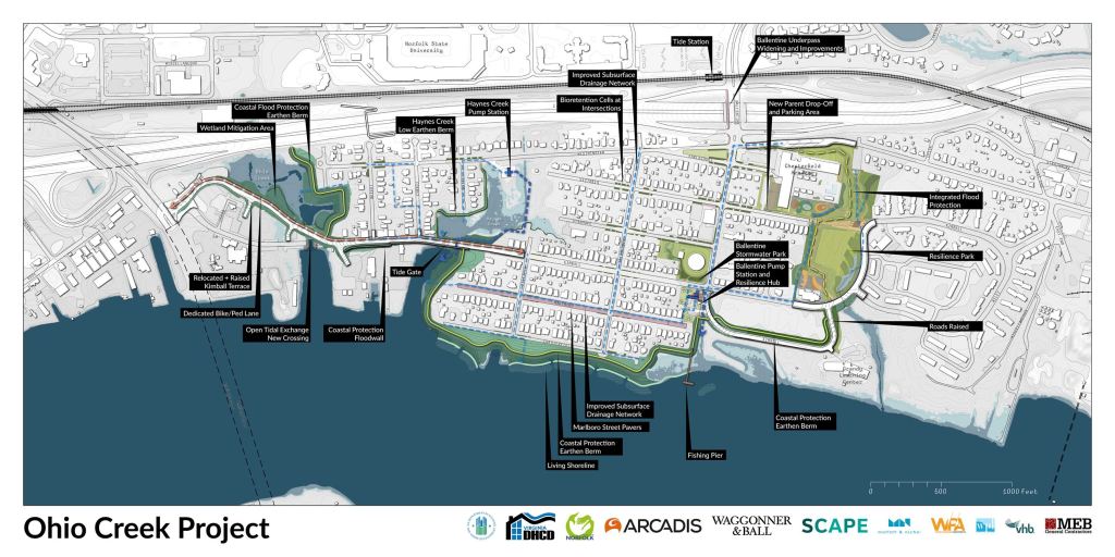
As this institutional engine begins to spin, the designs at Chesterfield Heights have evolved from student projects to massive government intervention. In May, I stood on a new berm stretching the length of Chesterfield Heights’ riverfront, about a mile long, parallel to Chesterfield Boulevard. Eight feet high and freshly planted with grasses, it feels like a giant, hardened sand dune, for now, gracefully curving with the shore. You can see the front and side yards of old river-facing houses from the top of the berm. The river is a little narrower here than downtown. Barges loaded up with timber pass by. And you can also see into Ohio Creek, the tributary that gives this assemblage of interventions or adaptations their award-winning name: The Ohio Creek Watershed Project.
The City of Norfolk was awarded a 112 million dollar federal grant as part of HUD’s National Disaster Resilience Competition. The post-reward construction threw the neighborhood into a years-long state of constant construction as the city, state, and contracting crews raced to keep up with federal deadlines.
The mini-projects categorized within the Ohio Creek mega project are between hard and soft or gray and green infrastructure. Gray infrastructure includes road raisings that heighten the elevation of critical entrances to the neighborhood and create flood walls. Additionally, the infrastructure features a gate that directs the flow of water in and out of Ohio Creek and a new and improved (enlarged) drainage system underneath the neighborhood. Two powerful pump stations- more traditional piped solutions mainly operate beneath the surface. The green infrastructure includes wetland construction and mitigation and creek restoration. New landscape features will be bioswales and rain gardens integrated into neighborhood streets, a new fishing pier, and a resilience park outfitted with ornamental, water-themed paving connecting the neighborhood to Grandy Village public housing. With the planting of hundreds of trees, even the pump stations, the modern engineering technology underlying the new green infrastructure, are thoughtfully designed as public spaces.

This green-gray dynamic is not an either/or situation. Projects that receive federal funding routinely feature elements of both, incorporating nature-based design or green infrastructure into modern engineering. Take the Hoben Resiliency Park in Hoboken, New Jersey; for example, trees, gardens, and green space filter a million gallons of water by design, while underneath, a giant tank stores another million.
It can be hard to get through the rhetoric surrounding the heart of the concept of resilience, a movement that policymakers have adopted as a rallying call toward a more sustainable way of building and managing cities. As opposed to traditional water management, which conveys stormwater straight into centralized sewer systems, resilient water management tries to engineer ways to deal with temporary influxes of water within urban areas, hence the slogan ‘living with water.’ In this way, water is captured or stored by decentralized landscape features or sponges that soak up water at the source:
- More trees on the street.
- Gardens with rooted plants between the sidewalk and curb.
- Pavement that lets water filter through to the soil.
These sponges can integrate into streetscapes, parks, schools, front yards, and parking lots. They can positively impact water quality, air quality, and even property values if appropriately designed.
In some ways, it is a conservation effort. In some ways a beautification campaign. In all, a monumental effort to fortify the city against nature and a political campaign to stabilize creeping flood insurance rates. Looking ahead, the future, if anything, will be expensive. Tourist brochures proudly advertise Norfolk’s 200 miles of shoreline. It took about 130 million to fortify about one or two, and even the new interventions of Chesterfield Heights are not necessarily designed to handle the severe weather of an intense hurricane. City officials say the efforts will make the neighborhood viable for 50, 75, and 100 years. City officials also say that an extensive and lengthy process involving the community’s residents has resulted in a project that addresses things that, at first glance, fall outside the scope of water management, like access to transportation and recreation. In sum, the upcoming strategies in and around Chesterfield Heights make up a compelling example of possible synergy when neighborhood planning, park design, and stormwater management integrate into the same (well-funded) process; a glimpse of what is to come for the rest of the city.

")


